

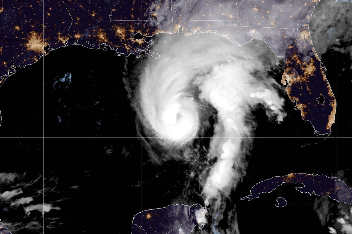
Hurricane Isaias is aiming at the northern Gulf Coast, roughly 850 miles from Baltimore, yet Maryland will not escape the storm entirely. The moisture it drags inland is forecast to reach the Baltimore area late Saturday night and keep it wet through Sunday, with a chance of thunderstorms before the system clears on Monday.
The National Weather Service forecast for Baltimore, updated at 2:22 a.m. Friday, calls for showers after 2 a.m. Sunday, a 100% chance of rain during the day Sunday and showers with a possible thunderstorm Sunday night.
Where is Hurricane Isaias now?
At 1 a.m. CDT Friday, the National Hurricane Center placed Isaias at 25.8 degrees north and 88.4 degrees west, moving north-northeast at 14 mph with maximum sustained winds of 105 mph, a Category 2 hurricane. Hurricane Hunter aircraft from NOAA and the Air Force were flying inside the storm.
A hurricane warning runs from Ocean Springs, Mississippi, to the Bay and Gulf county line in the Florida Panhandle, and landfall is expected late Friday or early Saturday between Gulf Shores, Alabama, and Pensacola, FOX Weather reported. Isaias is the first Atlantic hurricane of the 2026 season, which the FOX Forecast Center called the latest first hurricane since the satellite era began in 1966.
When will the rain reach Baltimore?
The storm is expected to weaken over the Southeast on Saturday and turn its remnants north. The Weather Channel lists Baltimore, Washington, Philadelphia and New York among the cities in line for rain on Sunday. Here is how the NWS breaks down the weekend for the city:
| Period | NWS Baltimore forecast | Chance of rain |
|---|---|---|
| Friday | Partly sunny, high near 76 | Dry |
| Saturday | Mostly cloudy, high near 73, east wind in the afternoon | Dry |
| Saturday night | Showers after 2 a.m., low around 61 | 80% |
| Sunday | Showers, high near 70 | 100% |
| Sunday night | Showers and possibly a thunderstorm, low around 64 | 80% |
| Monday (Columbus Day) | Showers likely before 8 a.m., then a chance of showers until 2 p.m.; partly sunny, high near 74 | 60% |
That leaves Friday and most of Saturday dry for outdoor plans. Sunday is the day to move indoors.
How much rain could Isaias bring to Maryland?
Forecasters were still refining totals on Friday. FOX 5 DC meteorologist Tucker Barnes estimated a half inch to an inch of rain for the Washington region by Monday morning and said he did not expect high-impact winds or dangerous flooding there. In Baltimore, FOX45 framed Sunday as a washout:
“Rain from this system arrives in Maryland by Sunday morning with soaking rain throughout the day.”
FOX45 Baltimore forecast, Oct. 8
FOX45 also warned that a few strong storms with gusty winds are possible. Remnant tropical systems can produce narrow bands of heavier rain, so totals can vary widely over short distances. Check the latest forecast Saturday evening before you commit to Sunday plans.
Which Baltimore-area spots flood first?
An inch of rain spread over a day is usually manageable, but heavier bands can quickly overwhelm storm drains, especially in October, when fallen leaves clog inlets. Places that have flooded in past downpours deserve extra caution:
- Ellicott City’s Main Street, where flash floods in 2016 and 2018 turned the historic district into a river.
- Low points along the Jones Falls and Gwynns Falls, including underpasses and roads near stream crossings.
- Neighborhood streets with clogged inlets. Clearing leaves from the drain in front of your home before Saturday night is the single most useful thing you can do. Clogged drains in the city can be reported to Baltimore 311.
The NWS rule still applies: if water covers the road, turn around. A foot of moving water is enough to carry away most cars.
Isaias is a familiar name in Maryland
The name is back because the World Meteorological Organization did not retire it after 2020, and Atlantic name lists repeat every six years. The first Isaias left a mark on the state. On Aug. 4, 2020, that storm produced ten confirmed tornadoes in Maryland, including EF2 twisters near Mardela Springs in Wicomico County and from George Island Landing to Girdletree in Worcester County, and an EF1 in Solomons. A man was killed in St. Mary’s County when a tree fell on his moving vehicle, and about 400,000 people lost power across Maryland and Virginia. Baltimore handed out free sandbags ahead of the storm.
This time the setup is different. The 2020 storm raced up the East Coast while it was still tropical. The 2026 version comes ashore on the Gulf Coast and reaches the Mid-Atlantic as weakening remnants after crossing the Southeast, which is why forecasters are focused on rain rather than wind.
Traveling to Atlanta for Ravens-Falcons?
The Ravens visit the Falcons for Sunday Night Football at 8:20 p.m. ET on NBC and Peacock, according to the team schedule. Atlanta is in the path of Isaias on Saturday, when The Weather Channel expects some of the worst inland conditions there. The game itself is played indoors, but fans flying out of BWI on Saturday should check their flight status and airline travel alerts before heading to the airport. The team comes off a 24-18 win over the Titans and a trade for center Cam Jurgens.
What to do before Sunday
- Clear leaves from gutters, downspouts and the storm drain nearest your home.
- Move Sunday outdoor plans to Saturday or Monday afternoon, when the forecast improves.
- Charge phones and turn on weather alerts in case thunderstorms knock out power Sunday night.
- Avoid parking in spots that flood, especially near streams and in low-lying lots.
- Follow the Baltimore City Office of Emergency Management and the Maryland Department of Emergency Management for official updates.
This story will be updated if forecasters change the timing or totals for Maryland.
Featured image: Hurricane Isaias in the northern Gulf early Friday, Oct. 9. Photo: NOAA/NESDIS/STAR, GOES-19 GeoColor.