

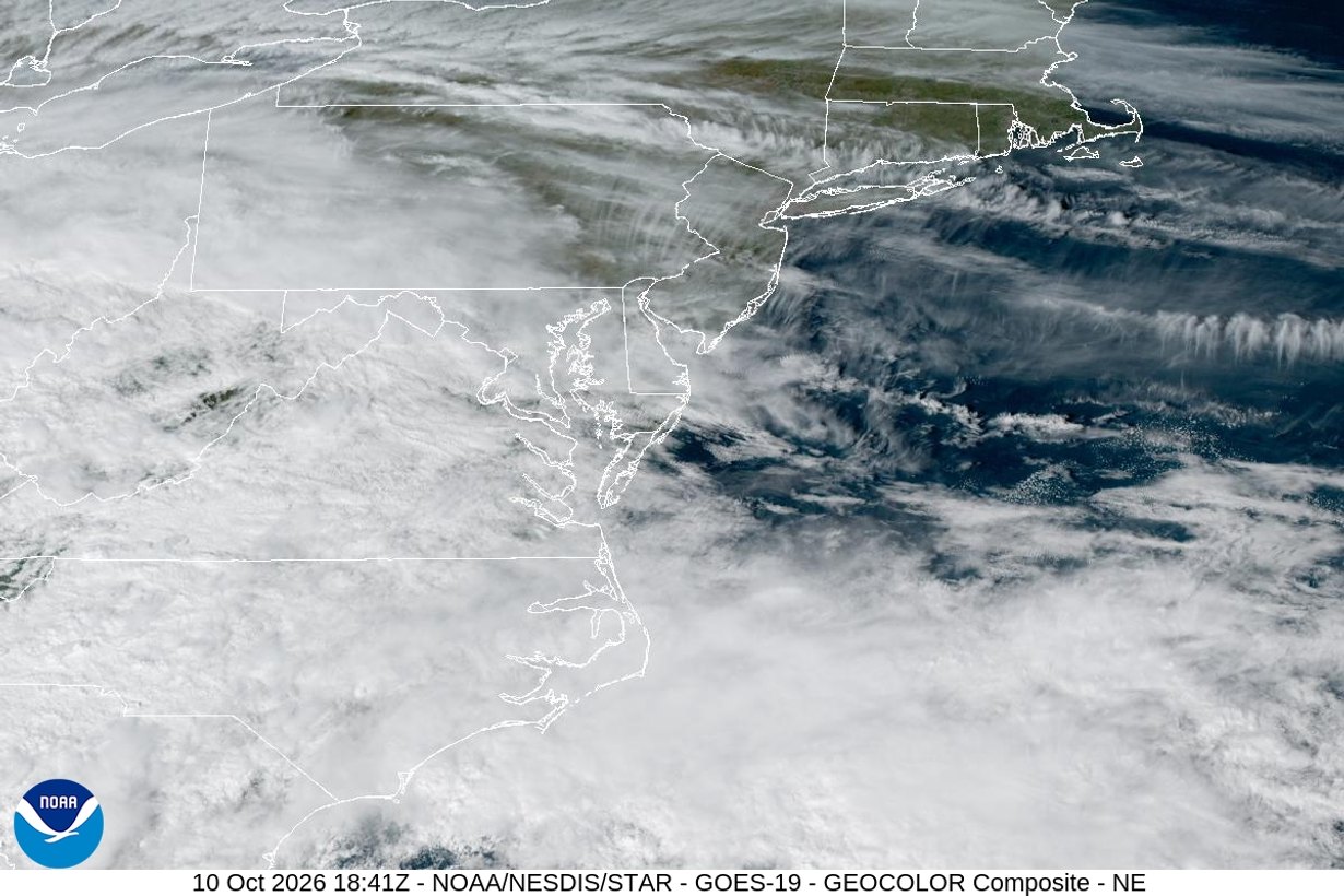
The remnants of Hurricane Isaias are expected to bring a soaking rain and a chance of tornadoes to Maryland on Sunday, the National Weather Service said Saturday. For Baltimore-area residents, the riskiest stretch looks like Sunday afternoon, when breaks in the clouds could let short-lived rotating storms form as a weak low-pressure wave crosses the region.
Isaias made landfall near Destin, Florida, around 9:30 p.m. Friday as a Category 2 hurricane, The Baltimore Banner reported. By 10 a.m. CDT Saturday, it had weakened to a post-tropical cyclone over central Alabama with maximum sustained winds near 35 mph, moving north-northwest at 10 mph, according to the National Hurricane Center. Our earlier forecast on how Isaias could affect Baltimore this weekend covers the rain outlook in more detail.
How likely are tornadoes in Maryland on Sunday?
The risk is real but limited. In its Saturday morning forecast discussion, the National Weather Service office in Sterling, Virginia, which covers Baltimore and Washington, listed “the threat of tornadoes Sunday” among its key messages. Forecasters said tornadoes and damaging wind gusts are the main threats and that the activity “looks mostly to be east of the Blue Ridge,” which includes central Maryland.
The federal Storm Prediction Center placed parts of Virginia and North Carolina under a Slight Risk (level 2 of 5) of severe storms for Sunday. According to the Sterling office, a Marginal Risk (level 1 of 5) extends north to the Maryland-Pennsylvania line. The center’s outlook said isolated severe storms “capable of producing gusty winds and a tornado or two” will be possible across parts of the Mid-Atlantic.
The big unknown is instability. Forecasters said thick clouds and rain could keep the atmosphere stable; if the sun breaks through for a few hours Sunday afternoon, wind shear left over from Isaias would be strong enough to support rotating storms.
When will the worst weather hit Baltimore?
Rain spreads north Saturday evening and night, with heavy tropical moisture arriving after midnight. The steadiest rain is expected Sunday morning into early afternoon. The window for severe storms follows Sunday afternoon and evening, and the remnants push offshore Monday.
| Time | What to expect in central Maryland |
|---|---|
| Saturday evening and night | Rain moves in from the south; heavier tropical downpours after midnight |
| Sunday morning to early afternoon | Steady, heavy rain; 1.5 to 2.5 inches total, locally 3 to 4 inches |
| Sunday afternoon and evening | Possible breaks in clouds; isolated severe storms with damaging gusts and a tornado or two |
| Sunday evening high tide | Minor coastal flooding possible along the Chesapeake Bay |
| Monday | Isaias remnants move offshore; showers end, warm and humid |
Gusts are forecast at 20 to 30 mph in most of the region, according to the weather service. Wind advisories are in effect for the Allegheny Mountains, including western Garrett County, and the Blue Ridge, where gusts could reach 40 to 50 mph. No flood watch had been issued as of Saturday morning because the heaviest rain is expected in areas that can handle it, forecasters said. CBS Baltimore noted the rain is not expected to end the state’s drought.
Has Isaias caused tornadoes in Maryland before?
Yes. Atlantic storm names rotate every six years, and the 2026 list repeats the one used in 2020, when Tropical Storm Isaias crossed Maryland on Aug. 4. The National Weather Service confirmed four tornadoes in Southern Maryland that morning, CBS Baltimore reported: an EF-0 near Ridge and an EF-1 near Piney Point in St. Mary’s County, and two EF-1 tornadoes in Calvert County near Dares Beach and Plum Point. The Piney Point tornado had peak winds of 100 mph. Additional suspected tornadoes were reported on the Lower Eastern Shore.
Sunday’s setup is different: the 2026 storm arrives as a weaker post-tropical system, and forecasters expect only isolated severe storms. But the 2020 storm shows how quickly tropical remnants can produce brief, fast-moving tornadoes in Maryland, often with little warning.
What is the difference between a tornado watch and a tornado warning?
- Tornado watch: Conditions are favorable for tornadoes across a broad area. Keep your phone charged and know where you would shelter.
- Tornado warning: A tornado has been spotted or indicated by radar. Take shelter immediately.
- Where to go: The lowest floor of a sturdy building, in an interior room without windows, such as a basement, bathroom or closet.
- Alerts: Make sure Wireless Emergency Alerts are turned on in your phone settings, and consider a NOAA weather radio. Baltimore City and the counties also offer local alert sign-ups.
“Just stay as safe as you can be with any impactful weather.”
Samantha Timmers, National Weather Service meteorologist, to The Baltimore Banner
What else should Marylanders watch for Sunday?
Annapolis officials expect coastal flooding in low-lying areas with Sunday’s high tides; see our report on the Annapolis coastal flood watch and City Dock. The Washington Commanders host the New York Giants at 1 p.m. Sunday at Northwest Stadium in Landover, and the team was monitoring the forecast, the Banner reported. The Ravens play at Atlanta Sunday night in a stadium with a retractable roof.
Travelers should check flight status before heading to BWI Thurgood Marshall Airport, and drivers should avoid flooded roads. Forecasts can change quickly with tropical remnants, so check the latest from the National Weather Service before making Sunday plans.
Featured image: GOES-19 GeoColor satellite view of the Northeast and Mid-Atlantic on Oct. 10, 2026, as clouds from Isaias’ remnants spread over the region. Photo: NOAA/NESDIS/STAR, public domain.